Image Estimation by Example: Geophysical Soundings Image Construction
by Jon Claerbout, Sergey Fomel
Publisher: Stanford University 2008
Number of pages: 330
Description:
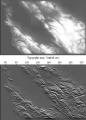
This book is about the estimation and construction of geophysical images. Geophysical images are used to visualize petroleum and mineral resource prospects, subsurface water, contaminant transport (environmental pollution), archeology, lost treasure, even graves. People need more practice with easier problems like the ones found in this book, which are mostly simple 2-D landforms derived from 2-D data. Such concrete estimation problems are solved quickly, and their visual results provide experience in recognizing weaknesses, reformulating, and moving forward again.
Download or read it online for free here:
Download link
(9.5MB, PDF)
Similar books
 Seismic Wave Propagation in Stratified Media
by Brian Kennett - ANU Press
The book presents a systematic treatment of the interaction of seismic waves with Earth structure. The theoretical development is physically based and is closely tied to the nature of the seismograms observed across a wide range of distance scales.
(8974 views)
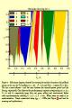
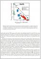 Geo-neutrinos
by G. Bellini, et al. - arXiv
We review a new interdisciplinary field between Geology and Physics: the study of the Earth's geo-neutrino flux. We describe competing models for the composition of the Earth, geological insights into the make up of the continental and oceanic crust.
(6768 views)
 Why could ice ages be unpredictable?
by Michel Crucifix - arXiv
It is commonly accepted that the variations of Earth's orbit and obliquity control the timing of Pleistocene glacial-interglacial cycles. Evidence comes from analysis of palaeoclimate records. However, we do not know how tight this control is.
(6213 views)
 Engineering Seismology, Geotechnical and Structural Earthquake Engineering
by Sebastiano D'Amico (ed.) - InTech
The book deals with different topics aiming to mitigate geo-hazards: Seismic hazard analysis, Ground investigation for seismic design, assessment and remediation, Earthquake site response analysis and soil-structure interaction analysis.
(8888 views)