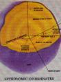
Geodesy for the Layman
by Richard K. Burkard
Publisher: Defense Mapping Agency 1984
Description:
The publication attempts to develop an appreciation of the scope of geodesy and to generate some understanding of the problems encountered in the science. The basic principles are presented through discussions of various geodetic topics such as: ellipsoids, geoid, horizontal surveying, leveling, geodetic datums and gravity.
Download or read it online for free here:
Read online
(online html)
Similar books
 Living with Earthquakes in the Pacific Northwest
by Robert S. Yeats - Oregon State University Press
Robert Yeats, a leading authority on earthquakes in the Pacific Northwest, describes the threat posed by the Cascadia Subduction Zone, a great earthquake fault which runs for hundreds of miles offshore from British Columbia to northern California.
(5627 views)
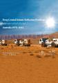 Deep Crustal Seismic Reflection Profiling
by B.L.N. Kennett, et al. - ANU Press
This book presents the full suite of reflection profiles penetrating the whole crust carried in Australia. The set of reflection data provides an insight into the variations in crustal architecture in the varied geological domains.
(4185 views)
 Basic Earth Imaging
by Jon F. Claerbout Cecil, Ida Green
The main theme of Basic Earth Imaging is to take a good quality reflection seismic data set from the Gulf of Mexico and guide you through the basic geophysical data processing steps from raw data to the best-quality final image.
(13215 views)
 Applied Geophysics
by Nicholas Rast - Pergamon Press
A selection of papers published in the Soviet journal Applied Geophysics are being presented to the Western scientists. The intention is to illustrate some of the achievements of the Russian applied geophysicists by translating their publications.
(15101 views)